1840-1
GENERAL GUIDE
Module No. 1840
Congratulations upon your selection of this CASIO watch. To get the most out
of your purchase, be sure to carefully read this manual and keep it on hand
for later reference when necessary.
About this manual
· Button operations are indicated using the letters shown in the illustration.
· Each section of this manual provides basic information you need to
perform operations in each mode. Further details and technical information
can also be found in the "REFERENCE" section.
Display Indicators
The following describes the indicators that
appear along the bottom of the display.
LIGHT
MENU
GPS
Indicator
GPS
AUTO
SAVE
2D
3D
ALM
SIG
BATT
Description
· Watch is in the GPS Mode.
· Flashes when the watch is performing a GPS measurement
operation.
Watch is in the GPS Auto or Continuous Mode.
Watch is in the GPS One-shot or Auto Mode.
Watch is performing a 2-dimensional GPS measurement (using
three satellites). This is the type of measurement normally used
in the Quick, One-Shot, and Auto Mode.
Watch is performing a 3-dimensional GPS measurement (using
four or more satellites), which provides better accuracy than
2D. This is the type of measurement used in the Continuous
Mode when data is obtained from four or more satellites.
Alarm is turned on.
Hourly Time Signal is turned on.
Battery power is low and battery needs to be replaced.
Precautions
· The measurement functions built into this watch are not intended for
use in taking measurements that require professional or industrial
precision. Values produced by this watch should be considered as
reasonably accurate representations only.
· Though a useful navigational tool, a GPS receiver should never be used as
a replacement for conventional map and compass techniques. Remember
that magnetic compasses can work at temperatures well below zero, have
no batteries, and are mechanically simple. They are easy to operate and
understand, and will operate almost anywhere. For these reasons, the
magnetic compass should still be your main navigation tool.
· CASIO COMPUTER CO., LTD. assumes no responsibility for any loss or
any claims by third parties that may arise through the use of this watch.
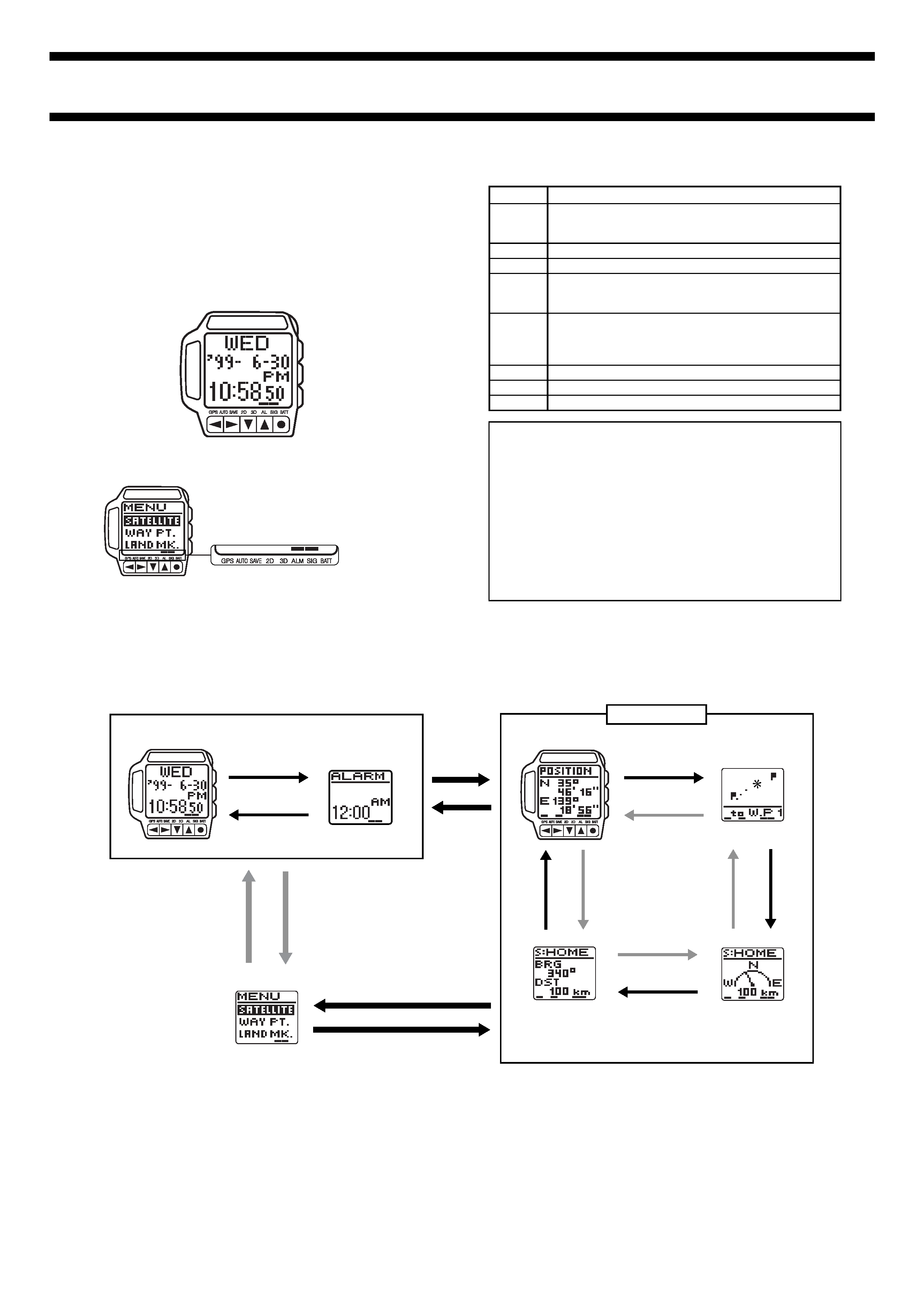
GETTING ACQUAINTED
· Use MENU and GPS to change between modes.
· In the GPS Mode, use L and K to change between screens.
· The watch beeps whenever you press a button to change to another mode
or screen.
Timekeeping Mode
Alarm Mode
Menu Screen
Graphical Navigation
Screen
GPS Mode
Position Screen
Plot Screen
Direction and Speed
Screen
Press
L or K.
Press GPS.
Press
L.
Press
K.
Press GPS.
Press MENU.
Press GPS.
Press MENU.
K
K
K
L
L
L
· You cannot go from the Menu Screen to the GPS Mode after displaying the
Menu Screen from the Timekeeping Mode or Alarm Mode. To get to the
GPS Mode in this case, you have to press GPS to return to the
Timekeeping Mode (or Alarm Mode) and then press GPS again to enter the
GPS Mode.
Press GPS.
1840-2
Using the Menu Screens
Many of the operations of this watch are performed using on-screen menus.
The following describes the general procedures for using on-screen menus.
To use the Menu Screens
· In any mode, press the MENU button to
display the Menu Screen.
· The highlighted menu item is the one that
is currently selected.
· Use L and K to move the highlighting.
The menu will scroll automatically if all the
items do not fit on a single screen.
· Press q to select the highlighted menu item. Selecting a menu item
sometimes displays another menu, and sometimes it displays some sort of
Setting Screen.
· Press the MENU button to back track through menus.
Adjusting Display Contrast
Use the following procedure to adjust the relative darkness of the figures on
the display.
To adjust display contrast
1. In any mode, press the MENU button
and the
H button at the same time to
display the Contrast Screen.
2. Use
K to increase contrast (making the
screen darker) and
L to decrease it.
· You can set contrast to one of 16 levels.
· The current contrast setting is indicated
by a value on the Contrast Screen.
3. After the contrast is the way you want, press MENU or q to return to the
screen you started from in step 1.
· You can also display the Contrast Screen using the following procedure:
Press MENU, highlight SET UP, press q, highlight CONTRAST, press q.
After setting the contrast, press MENU twice to return to the Menu Screen.
BACKLIGHT
Press the LIGHT button to illuminate the
display for about two seconds.
· The backlight is disabled while a GPS
measurement operation is in progress
(indicated when the GPS indicator is
flashing) and while the WAIT message is
on the display following a Set Up Menu
operation.
· The electro-luminescent (EL) panel that
illuminates the display loses illuminating
power after very long use.
· Illumination may be hard to see when
viewed under direct sunlight.
· The watch may emit an audible sound
while the backlight is on. This is normal
and does not indicate malfunction.
TIMEKEEPING MODE
Day of the week
PM indicator (AM indicator
for morning times)
Current time
Current date
(year, month, day)
Hold down q about
one second.
Hold down q about
one second.
Standard 12-hour
Timekeeping
Summer Time (DST)
12-hour Timekeeping
DST indicator
J
H
J
H
L
K
L
K
Press
H.
Press
H.
24-hour timekeeping
indicator
Standard 24-hour
Timekeeping
Summer Time (DST)
24-hour Timekeeping
To reset the seconds count to zero
1. In any mode, press the MENU button to display the Menu Screen,
highlight SET UP, and then press q to display the Set Up Menu.
2. Use
L and K to move the highlighting to TIME, and then press q.
3. While the seconds digits are flashing, press
K to reset them to zero.
· Pressing K while the seconds count is in the range of 30 to 59 resets it to
00 and adds 1 to the minutes. If the seconds count is in the range of 00 to
29, pressing
K resets it without changing the minutes.
4. After everything is the way you want it, press GPS to exit the Setting
Screen and return to the screen you started from in step 1.
Notes
· The year can be set in the range of 1995 to 2039.
· The day of the week is displayed automatically in accordance with the
month and day settings.
· The watch's built-in full automatic calendar makes allowances for different
month lengths and leap years. Once you set the date, there should be no
reason to change it except after replacing the watch's battery.
· The summer time or Daylight Saving Time (DST) Screen automatically
advances the current time setting by one hour. This is a practice followed
in certain geographic areas, and may or may not apply in your area.
Setting the Current Time and Date
Use the Menu Screen to set the current time and date, and to reset the
second's count to zero.
Important!
The GPS Mode of this watch uses the time and date settings to determine the
current positions of satellites. Make sure that your time and date setting are
always accurate.
To set the current time and date
1. In any mode, press the MENU button to display the Menu Screen.
2. Use
L and K to move the highlighting to SET UP.
3. Press q to display the Set Up Menu.
4. Use
L and K to move the highlighting to TIME, and then press q.
· This displays the current date and time setting, with the seconds digits
flashing.
5. Use
H and J to move the flashing around the display to the other digits
in the sequence shown below.
Seconds
Hour
Minutes
Month
Year
Day
Press
J.
Press
H.
6. While the hour, minutes, year, month, or day digits are selected (flashing),
press
K to increase them or L to decrease them.
· Holding down either button changes the flashing digits at high speed.
7. After everything is the way you want it, press GPS to exit the Setting
Screen and return to the screen you started from in step 1.
Use the Timekeeping Mode to view the current time and date. You can select
from among the four different Timekeeping Screen formats shown below.
1840-3
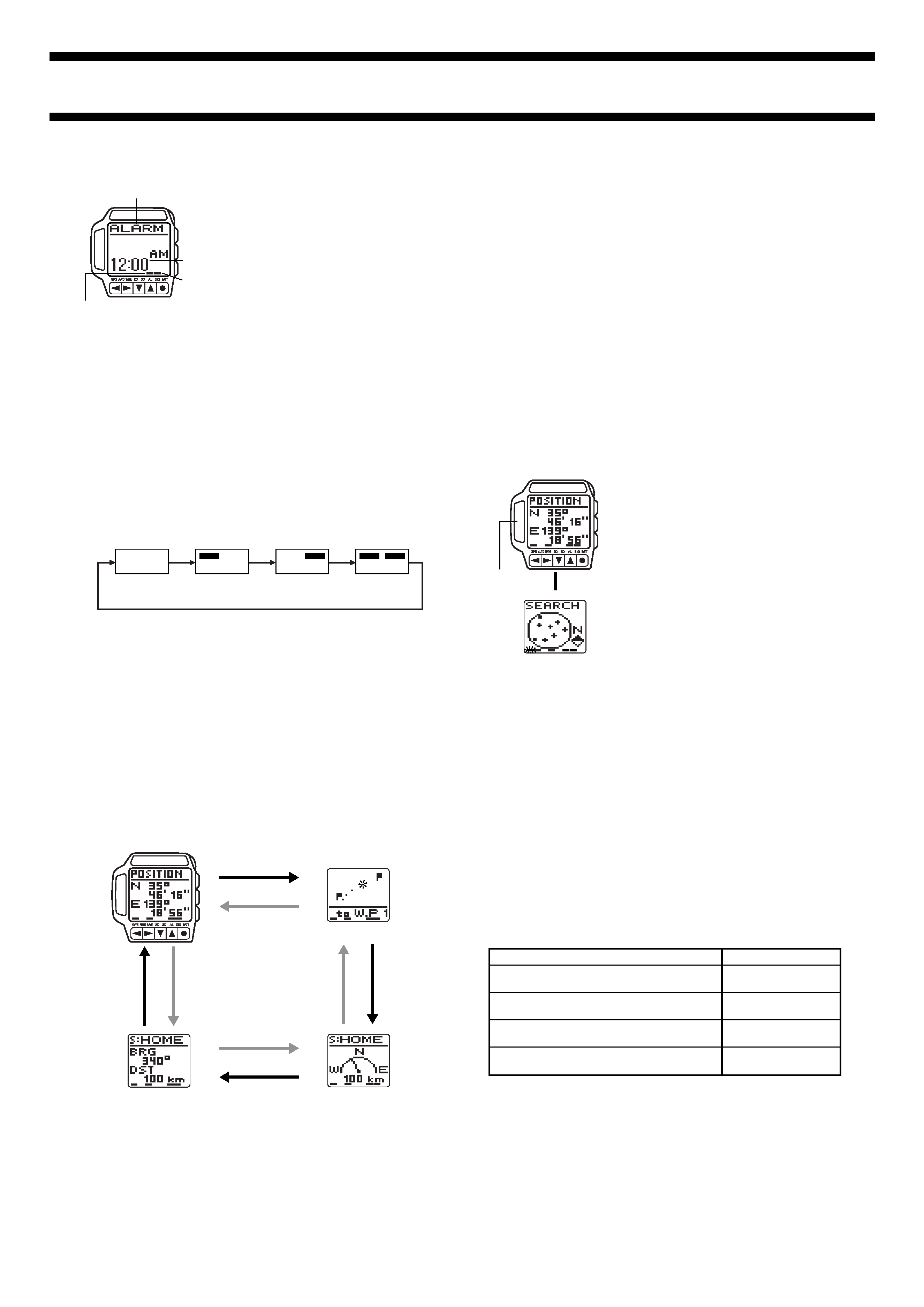
ALARM MODE
You can set an alarm time at which a beeper
sounds for about 20 seconds each day. Press
any button to stop the alarm.
The watch also has an hourly time signal that
beeps twice every hour on the hour when
turned on.
To set the alarm
1. In any mode, press the MENU button to display the Menu Screen.
2. Use
L and K to move the highlighting to SET UP.
3. Press q to display the Set Up Menu.
4. Use
L and K to move the highlighting to ALARM and then press q.
· This displays the current alarm time setting, with the hour digits flashing.
5. Use
H and J to move the flashing between the hour digits and the
minutes digits.
6. Press
K to increase the flashing digits or L to decrease them.
· Holding down either button changes the flashing digits at high speed.
7. After the alarm time is the way you want it, press GPS to exit the Setting
Screen and return to the screen you started from in step 1.
Hourly Time Signal
on indicator
Mode name
Alarm time
Alarm on indicator
To turn the alarm and Hourly Time Signal on and off
In the Alarm Mode, each press of q cycles through the alarm and Hourly Time
Signal on/off settings as shown below.
[Alarm On Indicator/Hourly Time Signal On Indicator]
· An indicator appears above ALM at the bottom of the display when the
alarm is turned on, and above SIG when the hourly time signal is turned on.
To test the alarm
In the Alarm Mode, hold down q to sound the alarm.
Both Off
Hourly Time
Signal On
Both On
Alarm On
ALM SIG
ALM SIG
ALM SIG
ALM SIG
GPS MODE
The GPS Mode provides you with a collection of powerful GPS functions that
allow you to determine your current position and perform other useful
navigation operations. After entering the GPS Mode, use the
L and K
buttons to cycle through four GPS Data Screen formats as shown below.
GPS Data Screens
· The Position Screen appears first whenever you enter the GPS Mode.
Plot Screen
Press
K.
Press
L.
Graphical Navigation Screen
Direction and Speed Screen
Position Screen
L
K
K
L
L
K
Use:
Quick Mode
One-Shot Mode
Continuous Mode
Auto Mode
To perform:
One-shot measurement with standby for
subsequent measurements
One-shot measurement with no standby
(power save)
Continuous measurement with standby for
subsequent measurements
Continuous measurement with semi-standby
(power save)
Setting Up the GPS Mode
The following are settings you need to make before actually taking any
measurements with the GPS Mode. Most of these need to be made only the
first time you use the watch. See the referenced pages for full information
about each setting.
· Area setting (See "Setting Your Area")
· Datum setting (See "Setting a Datum")
· Distance unit setting (See "Setting the Distance Unit")
· Speed unit setting (See "Setting the Speed Unit")
Important!
· The Timekeeping Mode time and date settings are also used to determine
the current positions of satellites. Make sure that your time and date setting
are always accurate.
Taking a GPS Measurement
The following are the basic steps for taking a position measurement in the
GPS Mode. See the referenced pages in this manual for further details.
The following procedure uses the One-Shot Mode as an example. See "GPS
Measurement Modes" for information about other measurements.
Important!
· GPS measurements may take a long time to complete or may even be
impossible due to satellite and other conditions.
To take a GPS measurement
1. While a GPS Data Screen is on the
display, press q.
· This example procedure starts from the
Position Screen.
· This changes to the Satellite Search
Screen.
· The indicator flashes above GPS at the
bottom of the screen to indicate that the
watch is searching for overhead satellites.
· To interrupt an ongoing GPS
measurement, press q again.
· Make sure the antenna is pointing up at
the sky while a measurement is taking
place.
2. When the measurement is successful, the watch beeps a number of times
and returns to the GPS Data Screen you started from in step 1.
· See "To add a landmark by registering your current location" for information
about storing GPS measurement data in Landmark Memory.
· See "GPS Measurement Modes" for more information about indicators and
how the watch updates measurement data.
· If the watch is unable to successfully complete the measurement within
about two minutes, it plays a short tune and displays SATELLITE at the top
of the display to let you know. If this happens, press q twice to return to the
GPS Data Screen, move to a more open area, and try again.
· If you perform the above GPS measurement operation within the area
defined by 20
° to 46° north latitude and 122° to 149° east longitude, a
successful measurement causes a map of Japan to appear on the display
for a few seconds, followed by a GPS Data Screen.
GPS Measurement Modes
You can select from among four different GPS measurement modes. The
mode you should select depends on how quickly you want your position data
updated balanced against how important it is for you to conserve remaining
battery power.
Remember, however, that no matter which GPS measurement mode you use,
it can take a considerable amount of time to achieve the first measurement.
· The standby modes provide faster updating of measurement data following
the first measurement, but they consume more battery power because the
watch's GPS circuit remains in standby (half power). The indicator flashing
above GPS at the bottom of a GPS Data Screen indicates that GPS
measurement is in standby.
L
Antenna
1840-4
· The non-standby modes take longer to produce subsequent
measurements, but shutdown of the watch's GPS circuit between
measurements conserves battery power. In these modes, the indicator
above GPS at the bottom of a GPS Data Screen does not flash and an
indicator appears above SAVE to indicate power save is enabled.
Quick Mode
The Quick Mode performs a GPS measurement when you press q and
updates the GPS Data Screen. After the first measurement, the watch's GPS
circuit remains in standby, which is indicated by the flashing indicator above
GPS at the bottom of the GPS Data Screen. Because of this, subsequent
measurements are produced more quickly. Continuous Quick Mode standby
uses battery power. To exit standby, press
J while the Position Screen is on
the display to change to another measurement.
One-Shot Mode
The One-Shot Mode also performs GPS measurement when you press q and
updates the GPS Data Screen. In this mode, however, the watch's GPS circuit
is shut down between measurements. Because of this, it takes more time to
perform each measurement.
Continuous Mode
The Continuous Mode performs a GPS measurement every second starting
when you press q and ending when you press q again. The GPS Data
Screen is updated with each measurement. In the Continuous Mode, the
watch's GPS circuit remains in standby, which is indicated by the flashing
indicator above GPS at the bottom of the GPS Data Screen.
Auto Mode
The Auto Mode also performs a GPS measurement every minute starting from
when you press q and ending when you press q again. The GPS Data
Screen is updated with each measurement. Though the GPS circuit shuts
down between measurements in this mode, the indicator above GPS
continues to flash until you press q to stop measurement.
Important!
· The indicator flashing above GPS at the bottom of a GPS Data Screen
indicates that the GPS circuit is activated, which consumes valuable battery
power. To prolong battery life, be sure to use the following operations to
turn off the GPS circuit when you are not using it.
· Press q to stop position measurement and turn off the GPS circuit. The
indicator above GPS stops flashing at this time.
To select a GPS measurement mode
While the Position Screen is on the display in the GPS Mode, press
J to
cycle through the GPS measurement modes in the sequence shown below.
Quick Mode
One-Shot Mode
Continuous Mode
Auto Mode
Press
J.
Position Screen
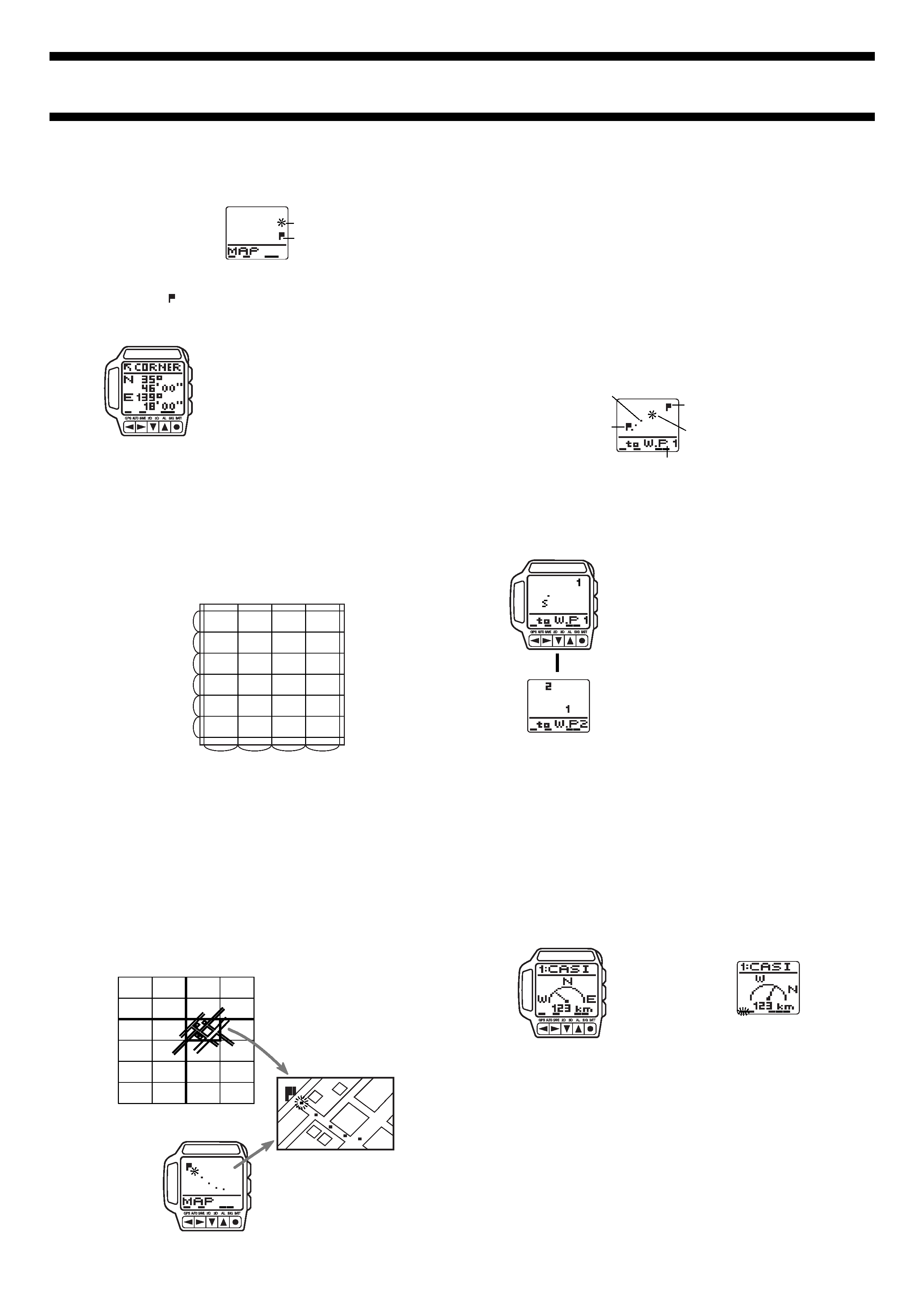
· The Position Screen shows your current
position in terms of latitude and longitude.
· Latitude is indicated as N (north) or S
(south), and longitude as E (east) or W
(west).
Plot Screens
The Plot Screens show your current location and your progress (tracks) from
one waypoint to another.
· See "Track Memory" for information about tracks and how they are stored
in memory.
· With the Plot Screens, the top (12 o'clock position) of the watch's display is
always north.
Screen virtual
width
Destination waypoint number
(W.P 1 = Waypoint 1)
Map Screen
Waypoint Plot Screen
Latitude
Longitude
J
H
Press
J.
J
J
Plot Screen Formats
There are two Plot Screen formats: a Map Screen and a Waypoint Plot Screen.
· Press J to toggle between screen formats.
· The Map Screen shows tracks and your current position inside the grid cell
where your current position is located.
· The Waypoint Plot Screen normally shows the two waypoints between
which your current position is located. You can also scroll to view other sets
of waypoints along your route.
· When you change to the Map Screen, a Map Scale Screen first appears for
about two seconds, followed by the Map Screen.
· When you change to the Waypoint Plot Screen, the virtual width of the
screen first appears for about two seconds, followed by the Waypoint Plot
Screen.
Waypoints
Note that you must define waypoints in watch memory before you can use the
Waypoint Plot Screen. See "Using Waypoints" for information about defining
and managing waypoints.
· The message NO W.P (no waypoints) appears on the screen if there are no
waypoints defined in the WAY PT. (waypoint) List.
Grid cell width
Grid cell height
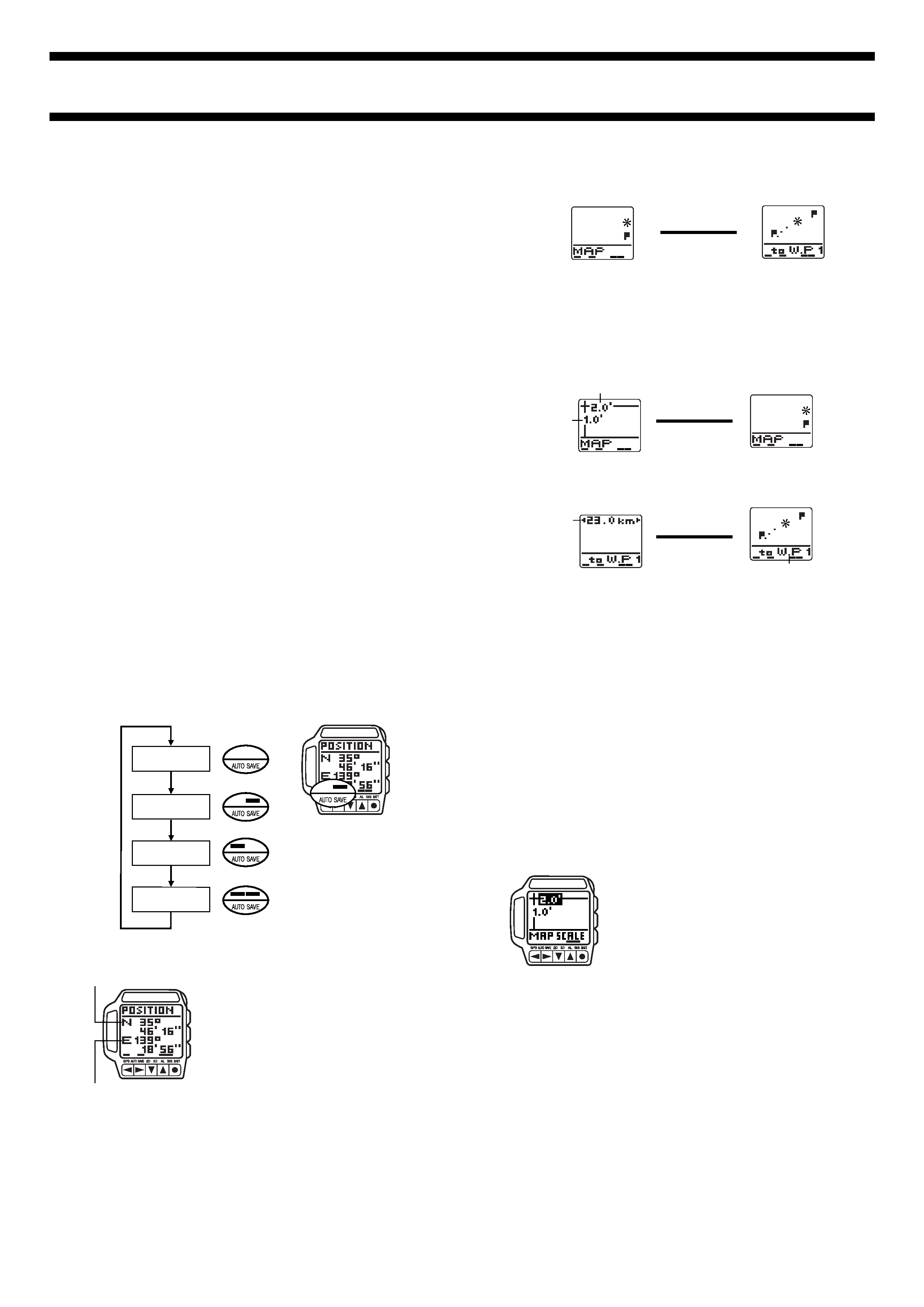
Using the Map Screen
Once you set up the Map Screen to match the gridlines on your paper map,
you can easily plot your position within a specific grid cell on the map. A
simple operation also lets you quickly determine which grid cell on the map is
currently shown on the Map Screen of the watch.
· See "Maps and Gridlines" for information about the types of maps that are
compatible with the Map Screen.
· See "Map Scale Settings" for other important information about the map
scale.
Important!
· The Map Screen of this watch is designed for use with maps that indicate
latitude and longitude down to minutes. It will not work properly with maps
that indicated latitude and longitude in degrees only.
To set up the Map Screen to match the gridlines of your map
1. In any mode, press the MENU button to
display the Menu Screen.
2. Use
L and K to move the highlighting
to SET UP and then press q to display
the Set Up Menu.
3. Use
L and K to move the highlighting
to MAP SCALE and then press q to
display the Map Scale Setting Screen.
· The values on the Map Scale Setting
Screen are for specifying the vertical-to-
horizontal ratio (in minutes) of each grid
cell on the map you are using. 1:2, for
example, indicates that grid cells are
twice as wide as they are high.
4. Use
H and J to move the highlighting between the vertical and
horizontal ratio values, and
L and K to change the highlighted value.
· See "Map Scale Settings" for full details about how your settings affect the
appearance of the screen.
5. After everything is the way you want, press q to return to the Set Up Menu
with DST UNITS highlighted.
6. Press the MENU button to return to the Menu Screen.
1840-5
GPS Measurement with the Map Screen
After successful measurement is achieved, your current position appears on
the Map Screen.
· See "Taking a GPS Measurement" for full details about GPS
measurements.
· Any waypoints ( ) located in the same grid cell as your current location
also appear on the display.
To determine your current grid cell
1. Set up the Map Screen to match the
gridlines of the map you are using.
· See "To set up the Map Screen to match
the gridlines of your map".
2. While your position is plotted on the Map
Screen, press
H to display the Corner
Screen.
· This screen shows the latitude and
longitude of the upper left corner of the
grid cell on your map where your current
position is located.
· See "Maps and Gridlines" for detailed
information about grid cells.
3. Press
H to return to the Map Screen.
· When you press H, the Map Scale Screen appears for about two seconds,
followed by the Map Screen.
Waypoint
Current position
(flashing)
Using the Map Screen for Navigation
Let's say you want to use the Map Screen to determine your position on a
paper map. Let us assume that your map is marked with lines creating grid
cells that are twice as wide as they are high.
1.0'
1.0'
1.0'
1.0'
1.0'
1.0'
2.0'
2.0'
2.0'
2.0'
Use the following procedure to set up the watch to match the map and to plot
your position on the map.
1. Use the procedure under "To set up the Map Screen to match the gridlines
of your map" to set the map scale.
· If you want waypoints to appear on the Map Screen, use the procedure
under "Using Waypoints" to define them.
2. Use the GPS Auto or Continuous mode to measure your position and plot
it on the screen as you travel towards your destination.
3. Use the procedure under "To determine your current grid cell" to locate the
currently displayed grid cell on your map.
4. Find the applicable grid cell on your map and you should be able to determine
your route by tracing the tracks that appear on the display of the watch.
· The example below shows the grid cell whose upper left corner is located
at 35
° 46' 00'' North latitude and 139° 18' 00'' East longitude.
47'
46'
45'
44'
43'
16'
18'
20'
Map
Watch display
Your route on the map
35
°48'
139
°14'
Using the Waypoint Plot Screen
The Waypoint Plot Screen shows preset waypoints in sets of two each, a
start
waypoint and a destination waypoint, along with track markers that indicate
your progress between the two points. The distance between start and
destination waypoints is scaled in order to allow both of them to fit on the
screen, so the
virtual width of the screen is adjusted automatically in
accordance with the actual distance between the two displayed waypoints.
Text at the bottom of the screen indicates the name of the next destination
waypoint, and you can specify kilometers, miles, or nautical miles as the unit
of measurement for the virtual width. When you reach a destination waypoint,
a simple operation changes it to your new start waypoint and displays the next
destination waypoint, automatically scaling the distance between them so they
both fit on the screen.
GPS measurement with the Waypoint Plot Screen
After successful measurement is achieved, your current position appears on
the Waypoint Plot Screen, along with your current start waypoint and
destination waypoint.
· Each waypoint is indicated on the display by a flag, which flashes
alternately with the applicable waypoint number.
· See "Taking a GPS Measurement" for full details about GPS
measurements.
To display the next set of waypoints
1. While the Waypoint Plot Screen is on the
display, press
H to display the next set
of waypoints.
2. The virtual width of the screen for the
new start and destination waypoints
appears for about two seconds, followed
by the Waypoint Plot Screen.
· You can use the above procedure to view
upcoming waypoints to determine
changes in direction. Remember that the
top of the display is always north.
Current position
(flashing)
Waypoint
Waypoint
Tracks indicating
your movement
Destination waypoint number
(W.P 1 = Waypoint 1)
L
Graphical Navigation Screens
The Graphical Navigation Screen shows the distance and direction from your
current position to a destination waypoint. You can specify kilometers, miles,
or nautical miles as the unit of measurement for the distance.
· See "To set the distance unit" for information about how to set the units of
measurement.
Important!
· The Graphical Navigation Screen will not work properly unless you have
defined waypoints already. See "Using Waypoints" for information about
defining and managing waypoints.
Graphical Navigation Screen Formats
There are two Graphical Navigation Screen formats: a Fixed Direction Screen
and a Current Direction Screen.
· The Graphical Navigation Screen format is normally the Fixed Direction
Screen. It automatically switches to the Current Direction Screen only while
the watch is in the Continuous Mode and you are moving at a speed of
8kph or faster. The Current Direction Screen is refreshed with each new
successful position measurement.
· Both screens show the name of your destination waypoint, a pointer to the
next destination waypoint, and the distance to the next destination
waypoint.
· With the Fixed Direction Screen, the top (12 o'clock position) of the display
is always north, while with the Current Direction Screen the top of the
display is always your current direction of travel.
Fixed Direction Screen
Current Direction Screen